Camp 1: Elkhorn - July 31, 1920 (elevation 550)
 Seattle to Brinnon by boat. Five miles up logging railroad and six miles woods trail up Dosewallips valley to Elkhorn camp in moss carpeted forest on north bank of river. [Bailey, Winona. Third Olympic Outing. The Mountaineer 13, no. 1 (1920): 10.] From [Brinnon] the greater portion of the party walked while others rode on a little gas car about five miles up the logging railroad to Corrigenda Ranger Station where some weeks before our commissary had been unloaded, and thence by trail for six miles to Elkhorn Camp, a beautiful spot on the banks of the Dosewallips River. [1920 outing: album 1]
^ Top of Page
Camp 2: Northeast Burn - August 1, 1920 (elevation 2,850)
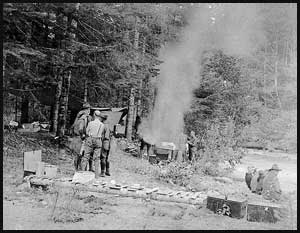
 Twelve miles forest trail up river to Northeast Burn, a widening of the valley closed behind by huge rock masses known as Mounts Deception and Mystery, the beckoning finger of Mount Claywood far ahead. [Bailey, Winona. Third Olympic Outing. The Mountaineer 13, no. 1 (1920): 10.] The next camp was twelve miles farther up the river, at an elevation of 2850 Ft., in a dry, hot, burned-off section in view of Mt. Mystery. [album 30] It must not be thought that this trip was a simple straight-away walk from Seattle to the ocean. The best planned tripthrough unfrequented mountain wilds is bound to encounter unforeseen obstacles. [Bailey, 14]
^ Top of Page
Camp 3: Dosewallips Basin - August 2-7, 1920 (elevation 5,980)
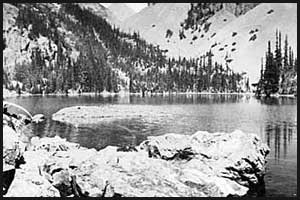
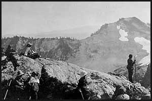
 Seven Miles forest and meadow to Dosewallips basin (5500 ft.) where the river heads below Hayden Pass (5980 ft.). Here camp was maintained five days. [Bailey, Winona. Third Olympic Outing. The Mountaineer 13, no. 1 (1920): 10.]The Dosewallips camp was voted by the party the most attractive of the outing. The river heads in one of those charming open parks such as one finds about Mount Rainier and in other parts of the Cascades, but which are of rarer occurance in the heavily forested Olympics where rugged rocks, snow-pocketed, rise abruptly above the forests. On an upper terrace under the shadows of Hayden Pass camp was located. The whole place was bright with flowers, grassy stretches leading off to groves of alpine fir and hemlock. A barrier ridge headed by Mount Sentinel, dropping to the saddle known as Hayden Pass and continuing to the summit rocks of Mount Claywood cut off distant views but challenged all who would greet the snow peaks to come higher. The effort of a climb to this garden wall was well rewarded and few there were who let a day pass without a look over the edge.[Bailey, 13]En route to Camp 2, a few strenuous hikers made a detour to Lake Constance, a very beautiful lake but difficult to reach.[1920 Outing: album 2]
^ Top of Page
Camp 3-1/2: Silt Creek - August 4, 1920
 Party of thirteen established temporary camp at Silt Creek in order to climb Mount Anderson the next day. On August 4 at 10 a.m. a party of thirteen under the leadership of Fairman Lee set out with knapsacks from Dosewallips camp for Mount Anderson. Crossing Hayden Pass they swung along the west side of Sentinel, through the pass between Sentinel and Sentinel's Sister, then keeping at the base of the rock wall that had caused the first scouting trip to fail, came to the base of the ledge the falls come over. Pulling themselves up the right hand side through vine maple and Alaska cedar, they emerged, to quote Mrs. Frazeur's account, "After seven hours of almost uninterrupted travel in a beautiful little valley above the falls of Silt Creek and followed the stream into a point near the glacier which gave it birth. Here we made temporary camp and enjoyed our frugal meal in the glory of a clear sunset in a valley of unsurpassed loveliness. The Silt meandered down the level floor of the valley, all dotted with tiny islands brilliant with a thick growth of fireweed; two splendid waterfalls dashed over the rocky wall above us, sharp peaks purple shadowed, rimmed with the little vale and at the end Mount Anderson, its broad snow fields rock turreted and crevassed closed the circle." [Bailey, 16]
^ Top of Page
Camp 4: Leitha Creek - August 8, 1920 (elevation 2,200)
 Eleven miles across Hayden Pass and down valley of the Hayes to the Elwha. Four miles up Elwha to Leitha Creek. The Hayes trail, considered one of the best in the Olympics, leads first through open park country, later along wooded hillside. [Bailey, Winona. Third Olympic Outing. The Mountaineer 13, no. 1 (1920): 10.]
^ Top of Page
Camp 5: Elwha Basin - August 9-13, 1920 (elevation 2,800)
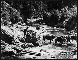
 Nine miles to Elwha Basin where four days were spent. In the first five miles the Godkin was crossed once and the Elwha four times by foot log. [Bailey, Winona. Third Olympic Outing. The Mountaineer 13, no. 1 (1920): 10.] Elwha basin still remains the necessary campsite for the upper Elwha. Its quarters are scarcely adequate for a large party but the place forms a convenient base for a number of climbs. An excellent trail was constructed this summer from the basin toward Dodwell-Rixon Pass. Starting up the left bank of the Elwha it crosses that stream at the mouth of the gorge and continues through forest and along hillside on the right bank until it meets the long snow finger coming down from Dodwell-Rixon Pass. Earlier in the season or in a summer when snows lie late, it would doubtless be possible to take horses on to the snow from this trail and thus on to Queets basin, but this year by August 10 the snow had so far melted that in a few places was fast becoming precarious even for a man. [Bailey, 13-14]
^ Top of Page
Camp 5-1/2: Queets Basin - August 10-11, 1920
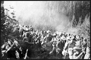
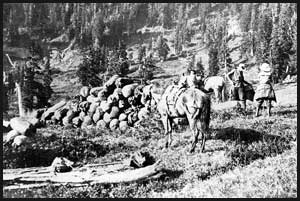
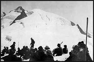 On August 10, the day after reaching Elwha basin, a party of fifty-backed from Elwha basin over the new Dodwell-Rixon Pass trail to Queets basin, preparatory to the climb of Olympus. During lunch at the pass on the shores of an iceberg lake, a bear was seen swimming in a lake on the bench below and a herd of fifteen elk sighted taking a siesta on a rocky prominence. Later, just as the party reached the stream flowing from the Humes glacier, several elk on the opposite side of the canyon came dashing down to the stream and disappeared up another trail. Deer, also, were seen next day by several. [Bailey, Winona. Third Olympic Outing. The Mountaineer 13, no. 1 (1920): 17.] A little distance away was a large ice cave. Next morning, the climb began over the lower part of Humes glacier which was a series of ice cascades, down to the Hoh glacier on up the glacier, where the party stopped to rest at a point near the summit. [1920 Outing: album 1]
^ Top of Page
Camp 6: Low Divide - August 14-15, 1920 (elevation 3,850)
 Four miles back down the Elwha and three miles up switchback trail to Low Divide (3850 ft.). The trail entirely through forest emerges at the divide into a mountain meadow, one of the best camp sites of the outing, where the last Sunday was spent. [Bailey, Winona. Third Olympic Outing. The Mountaineer 13, no. 1 (1920): 10-11.] The last opportunity for a climb was offered by Mount Christie from Low Divide. Miss Shelton, one of the twenty-five climbers of this year, remarked that this was the fifth recorded ascent of Mount Christie (6250 ft, aneroid reading), a Mountaineer party of fifty-six having climbed on the same date, August 15, seven years before. Her account concludes: "A fine panorama of the rugged peaks we would soon be leaving behind, a glimpse into our future haunts up Promise Creek and in the Quinault, the unusual experience of seeing and following an Elk on the glacier, and the discovery of a herd of thirty or thirty-five others in a valley below us made a fitting reward for our climb." (Bailey, 21-22)
^ Top of Page
Camp 7: Promise Creek - August 16, 1920 (elevation 5,000)
 Two miles west to Promise Creek near its junction with North Fork of Quinault, four miles up Promise Creek, on excellent new trail completed by Forest Service for this trip. Camp was made on site used only a few days earlier by trail crew. [Bailey, Winona. Third Olympic Outing. The Mountaineer 13, no. 1 (1920): 11.]
^ Top of Page
Camp 8: South Kimta Creek - August 17, 1920 (elevation 3,920)
 Eight miles to park at head of South Kimpta Creek (3920 ft.). This was the day of mist, the day of fine views when nothing was seen. The trail, entirely new, well marked and well built, leads to head of Promise Creek, crosses divide, and follows in general the Quinault-Queets watershed, keeping high on the Quinault side. The trail crew were still at work, and that very day at a place where a snowfield lay over rocks on top of the ridge made a new crossing for the horses, necessitated by melting of snow. [Bailey, Winona. Third Olympic Outing. The Mountaineer 13, no. 1 (1920): 11.] Our one day of rain came here, which brought out rain capes of many styles and colors. It also shut out the fine views we had hoped to have over the new trail, which led along the ridge to the camp on Kimta Creek. [1920 Outing: album 1]
^ Top of Page
Camp 9: Round Lake Trail- August 18, 1920
 Thirteen miles to camp near head of Round Lake trail. About ten miles, or as far as the Three Lakes trail was new, following the Quinault-Queets watershed through the country. [Bailey, Winona. Third Olympic Outing. The Mountaineer 13, no. 1 (1920): 11.] At the Finley Lookout Station, the party had its picture taken, and from there dropped down to the floor of the Quinault Valley with its giant moss covered spruce trees, on across the river where the wading was good, to the next to the last camp under the huge trees which border the shores of Lake Quinault. [1920 outing: album 1]
^ Top of Page
Camp 10: Lake Quinault- August 19, 1920
 Fourteen miles to Lake Quinault. First a knife-edge trail, then forest increasingly moss-festooned till floor of Quinault Valley was reached. Camp on south shore of lake two miles from Olsen. [Bailey, Winona. Third Olympic Outing. The Mountaineer 13, no. 1 (1920): 11.] The climax of many an outing is the big climb, but this outing was unique in that its high spots were three, the climb of Anderson, the climb of Olympus, and the canoe trip down the Quinault, but inasmuch as, contrary to expectation, everybody who desired had an opportunity to participate in it, the canoe trip became properly the climax of the outing.... A baker's dozen of canoes towed in double line across the lake, a cutting loose, a swing in broken order into the swift current of the river, the lap of paddle in clear deep water, the scraping of boat and pole over rocks, the noise of rapids ahead, the dark out-standing rocks avoided, the swaying branches from ever verdant banks, the low bridge of log-jam, the narrow passage with no space to spare above or at the side, the Siwash illahee in lonely spot among the trees, finally the deep black water, the distant roar of ocean, the Indian village of Taholah, the blood-red sun sinking into the waters of the Pacific, such was the close of the 1920 outing.[Bailey, 25]
^ Top of Page
Camp 11: Point Grenville- August 20, 1920 (sea level)
 Across Lake Quinault and thirty-five miles down Quinault river by canoe to Taholah. Three miles south on beach to Point Grenville where last camp was made among rocks on the seashore. [Bailey, Winona. Third Olympic Outing. The Mountaineer 13, no. 1 (1920): 11.] At sunset, we reached the little Indian village of Taholah and from there walked three miles south to our last camp on the beach at Pt. Grenville. The next morning, after walking down the beach to Moclips, we took the train for Seattle and so ended the 1920 Olympic Outing. [1920 Outing: album 1]
